Diagnostics
In modern structural engineering, diagnostics and identification are fundamental tools for infrastructural life cycle management. The Diagnostic department is responsible for in situ activities aimed at gathering and processing data to support the various disciplines
Benefits for project owner and customers
The survey and investigation are carried out using proprietary technologies and algorithms, cutting-edge techniques, and an interdisciplinary approach. Innovation is instrumental, in process and management, and enables the creation of a state-of-the-art IT environment for infrastructure maintenance, design, and operation.

The knowledge, preservation, and maintenance of heritage infrastructures is one of the most challenging matters facing modern civilization.
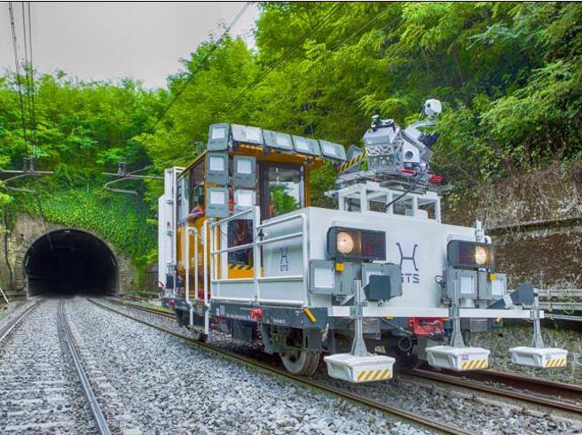
Digitization of infrastructure - MIRET
Preserving the integrity of infrastructure and the safety of people is our goal. Knowing and predicting the conditions of the infrastructure, allows us to adopt new strategies of planning and intervention. Digitization and data engineering become information to support the decision maker, this is the purpose of MIRET, the innovative methodology for diagnostics of existing tunnels through multidimensional mobile mapping systems and a new approach for risk management and identification supported by artificial intelligence allows to adopt a non-invasive, efficient, environmentally friendly approach.
Assets and Solution
ARCHITA
With her integrated instrumentation innovative multi-dimensional mobile mapping system and Tunnel Scan, allows us to acquire almost on defects and the information for the diagnostics of a structure with non-destructive tests. In such a way the process of visual inspection is automatized, digitalized, and back-officed.
MIRET e MIRETS
Approach the analysis of the elements focusing on integrated workflow to connect survey inspection data to geology, digitalization, diagnostic, and design. This approach can be defined through the following milestone: Survey and Inspection (SI), Infrastructure/Slope Digitalization (DI), Priorities Analysis (PA), Priorities Analysis (PA), Planning and Design (PD), Works and Maintenance (WM), Monitoring (MO)
B-SHAPE
ETS also implemented a USV with Bulti-beam Sonar for the bathymetric survey. The process data are integrated into a topographic survey to obtain a 3D reconstruction of both the above-sea and under-sea surface. Data acquired are used for study, the characterization of materials, and design solutions to reinforce the infrastructure and mitigate the erosion effect near the line. All data acquired, engineering, and geologist analysis are integrated into our innovative B-SHAPE software.
Diagnostic Slope Mapping
Catastrophic events like landslides and floods can cause significant social, economic, and infrastructure damage. Damage can be avoided and made more manageable by a proper system of warning and planning of ordinary or extraordinary maintenance. To respond to these issues, ETS has tools, technologies, and processes that can enable appropriate management and prioritization according to their potential manifestation. The infrastructure elements are digitized and the approach is based on logical and coordinated decisions in a digital and multidisciplinary environment for the management of risk scenarios, primarily for tunnels and hydrogeological instability.
In situ investigations and surveys
Earthscience performs geognostic and geotechnical investigations preliminary to the design of building and infrastructure interventions. Environmental surveys for the control of pollutants in the soil. Continuous core drilling, penetrometer tests, and in-situ tests are therefore performed to reconstruct the stratigraphic structure of the ground and its geotechnical characteristics